Start Slideshow


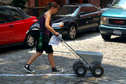

 High Water Line (2007), Eve MosherThe water line is rising along NYC's waterfront, and public works artist Eve Mosher is using her High Water Line project to make sure that we understand the very real effects of climate change along our shared urban coastline. From May to October 2007, Mosher is drawing (by-hand or pushcart) a white chalk line through the waterfront communities of Brooklyn and lower Manhattan in order to illustrate the 10-feet above sea level mark that potentially threatens unsuspecting neighborhoods, commercial zones, city streets, and private residences. High Water Line marks the extent of increased flooding brought on by stronger and more frequent storms as a result of climate change....<br><br><a href='https://inhabitat.com/the-high-water-line-public-art-in-nyc/'>READ ARTICLE</a>1
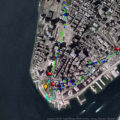 High Water Line (lower Manhattan map)The water line is rising along NYC's waterfront, and public works artist Eve Mosher is using her High Water Line project to make sure that we understand the very real effects of climate change along our shared urban coastline. From May to October 2007, Mosher is drawing (by-hand or pushcart) a white chalk line through the waterfront communities of Brooklyn and lower Manhattan in order to illustrate the 10-feet above sea level mark that potentially threatens unsuspecting neighborhoods, commercial zones, city streets, and private residences. High Water Line marks the extent of increased flooding brought on by stronger and more frequent storms as a result of climate change....<br><br><a href='https://inhabitat.com/the-high-water-line-public-art-in-nyc/'>READ ARTICLE</a>2
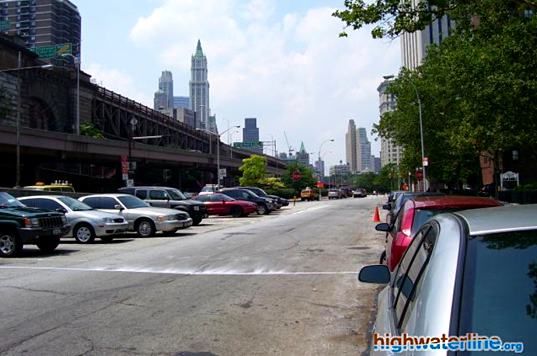
 Eve MosherThe water line is rising along NYC's waterfront, and public works artist Eve Mosher is using her High Water Line project to make sure that we understand the very real effects of climate change along our shared urban coastline. From May to October 2007, Mosher is drawing (by-hand or pushcart) a white chalk line through the waterfront communities of Brooklyn and lower Manhattan in order to illustrate the 10-feet above sea level mark that potentially threatens unsuspecting neighborhoods, commercial zones, city streets, and private residences. High Water Line marks the extent of increased flooding brought on by stronger and more frequent storms as a result of climate change....<br><br><a href='https://inhabitat.com/the-high-water-line-public-art-in-nyc/'>READ ARTICLE</a>3
 High Water Line (lower Manhattan)The water line is rising along NYC's waterfront, and public works artist Eve Mosher is using her High Water Line project to make sure that we understand the very real effects of climate change along our shared urban coastline. From May to October 2007, Mosher is drawing (by-hand or pushcart) a white chalk line through the waterfront communities of Brooklyn and lower Manhattan in order to illustrate the 10-feet above sea level mark that potentially threatens unsuspecting neighborhoods, commercial zones, city streets, and private residences. High Water Line marks the extent of increased flooding brought on by stronger and more frequent storms as a result of climate change....<br><br><a href='https://inhabitat.com/the-high-water-line-public-art-in-nyc/'>READ ARTICLE</a>4
-
High Water Line (lower Manhattan)The water line is rising along NYC's waterfront, and public works artist Eve Mosher is using her High Water Line project to make sure that we understand the very real effects of climate change along our shared urban coastline. From May to October 2007, Mosher is drawing (by-hand or pushcart) a white chalk line through the waterfront communities of Brooklyn and lower Manhattan in order to illustrate the 10-feet above sea level mark that potentially threatens unsuspecting neighborhoods, commercial zones, city streets, and private residences. High Water Line marks the extent of increased flooding brought on by stronger and more frequent storms as a result of climate change....<br><br><a href='https://inhabitat.com/the-high-water-line-public-art-in-nyc/'>READ ARTICLE</a>5
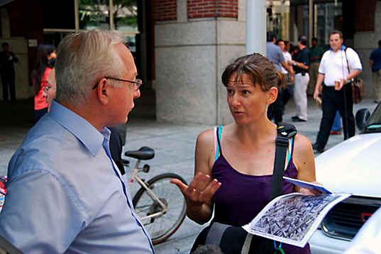
 Eve Mosher (in dialogue)The water line is rising along NYC's waterfront, and public works artist Eve Mosher is using her High Water Line project to make sure that we understand the very real effects of climate change along our shared urban coastline. From May to October 2007, Mosher is drawing (by-hand or pushcart) a white chalk line through the waterfront communities of Brooklyn and lower Manhattan in order to illustrate the 10-feet above sea level mark that potentially threatens unsuspecting neighborhoods, commercial zones, city streets, and private residences. High Water Line marks the extent of increased flooding brought on by stronger and more frequent storms as a result of climate change....<br><br><a href='https://inhabitat.com/the-high-water-line-public-art-in-nyc/'>READ ARTICLE</a>6
 Lower Manhattan waterfrontThe water line is rising along NYC's waterfront, and public works artist Eve Mosher is using her High Water Line project to make sure that we understand the very real effects of climate change along our shared urban coastline. From May to October 2007, Mosher is drawing (by-hand or pushcart) a white chalk line through the waterfront communities of Brooklyn and lower Manhattan in order to illustrate the 10-feet above sea level mark that potentially threatens unsuspecting neighborhoods, commercial zones, city streets, and private residences. High Water Line marks the extent of increased flooding brought on by stronger and more frequent storms as a result of climate change....<br><br><a href='https://inhabitat.com/the-high-water-line-public-art-in-nyc/'>READ ARTICLE</a>7
